Dies ist der vollständige Blog unserer Sommerreise durch Island, Grönland und die Färöer
Es ist unsere dreimonatige Reise durch Island einschließlich dem einwöchigen Abstecher nach Grönland und der Rückreise durch die Färöer von Mitte Mai bis Mitte August einschließlich der Zusammenfassung der Reise (in 7 Seiten):
This is the full blog of our summer trip through Iceland, Greenland and the Faroe Islands Die Eisberge des Jökulsárlón werden bei bestimmten Konstellationen von Gezeiten, Wellen und Eisabfluss nicht bzw. nicht alle in den offenen Atlantik geschwemmt. Einige oder sogar viele von ihnen werden dann auf den schwarzen Strand gespült, mit dem sie großartige Kontraste bilden. Die Wellen zerren an ihnen und die Gischt spritzt meterhoch. Diamonds on black velvet The icebergs of the Jökulsárlón are not swept into the open Atlantic, or not all, in certain constellations of tides, waves and ice drains. Some or even many of them are then flushed onto the black beach, with which they form great contrasts. The waves are tugging at them and the spray splashes meters high.
Auch hier haben wir wieder großes Glück. Auf hunderten Metern ist der Strand voll von Eisbergen, -klumpen, -brocken und -bröseln. Bei prallem Sonnenschein und tobender Brandung gibt es viel mehr zu sehen, als wir erfassen können. Here, too, we are very lucky again. On hundreds of meters the beach is full of icebergs, clods, chunks and crumbs. In a lot of sunshine and with a raging surf, there is much more to see than we can capture. Bei unserer achtzehntägigen Island-Reise im Juli und August 2007 hatten wir oft und recht anhaltend schlechtes Wetter. Jetzt hingegen sind wir offenbar in eine Art Island-Werbewoche geraten. Seit der Ankunft in Seyðisfjörður hatten wir eine Woche lang herrliches Frühlingswetter mit täglichem Sonnenschein, meistens von früh bis spät. Die Fotos in unserem Blog dokumentieren das. Die wenigen kurzen Schauer waren gut organisiert, sie fielen vorwiegend nachts. Selbst der häufig unangenehm kalte Wind konnte den Eindruck kaum trüben: Wetter wie gemalt. Auf dem Weg vom Jökulsárlón weiter südwestwärts nach Skaftafell zeigen sich über dem Öræfajökull, einem großen Ausläufer des Vatnajökull, die ersten dunklen Wolken. Und so gibt es einige andere typische Bilder aus Island, als bisher. End of the Iceland promotion week During our eighteen-day Iceland trip in July and August 2007, we often had quite bad weather. Now, in contrast, we obviously got into kind of an Iceland-promotion week. Since arriving in Seyðisfjörður we had a wonderful spring weather with daily sunshine for a week, mostly from early to late. The photos in our blog document this. The few short showers were well organized, they occured mainly at night. Even the often unpleasantly cold wind could scarcely becloud the impression: weather as if painted. On the way from Jökulsárlón further south-westwards to Skaftafell, the first dark clouds show up over the Öræfajökull, a large foothill of the Vatnajökull. And so there are some different typical pictures from Iceland than so far. Vor fünf Jahren war der Svínafellsjökull noch ein Geheimtipp unter Isländern. Der Weg dorthin von der Ringstraße war nicht markiert und nur zu für Eingeweihte zu finden. Jetzt hat er eine eigene Zufahrtsstraße, sogar mit Brücke. Ein Schild an einem Rastplatz der Ringstraße weist den Weg. Die gut zwei Kilometer lange Schotterstraße, die vor der Front des Skaftafellsjökull entlang zum Parkplatz vor dem Gletschersee führt, hat schon viele Schlaglöcher. Kein Wunder bei dem Andrang, sogar jetzt in der Vorsaison. Außer seiner guten Erreichbarkeit hat der Svínafellsjökull im Vergleich zu Jökulsárlón und z.B. Hoffellsjökull ein paar attraktive Besonderheiten. Der Gletscher fällt in kurzer Distanz vom Parkplatz recht steil ab und schiebt seine Eismassen tief ins Tal. Dort liegen sie direkt vor dem gut geschützten Platz, der sehr gute Sicht darauf bietet. Vom Parkplatz aus gibt es schöne Wanderwege an den See und zum Eis, das fast mit Händen greifbar ist. Die dunklen Wolken vom Vortag haben sich nicht lange gehalten. Und hier beginnen die Lupinen schon zu blühen. Pig mountain glacier Five years ago the Svínafellsjökull was still an insider tip among Icelanders. The way to get there from the ring road was not marked and only to be found for the initiates. Now it has its own access road, even with a bridge. A sign at a rest area at the ring road shows the way. The well two-kilometer-long gravel road, which runs in front of the Skaftafellsjökull to the parking lot at the glacier lake, already has a lot of potholes. No wonder at the rush, even now in the preseason. Apart from its good accessibility, the Svínafellsjökull compared to Jökulsárlón and e.g. Hoffellsjökull has a few attractive features. The glacier falls at a short distance from the parking lot quite steeply and pushes its ice masses deep into the valley. There they are right in front of the well-protected place, which offers a very good view. From the car park there are beautiful hiking trails to the lake and to the ice, which is almost palpable with hands. The dark clouds of the previous day did not last long. And here the lupins begin to bloom already. Der Svartifoss ist ein Klassiker unter den isländischen Attraktionen. Schon von weitem ist er in seiner großen „Bühne“ zu sehen. Aus der Nähe ist er mit seinem umgekehrten „Amphitheater“ einfach nur beeindruckend, gerade auch wegen der schwarzen Basalte. The black waterfall The Svartifoss is a classic among the Icelandic attractions. From a distance already it can be seen in its large „stage“. Close up with its inverted „amphitheater“ it is just impressive, especially because of the black basalts. Skaftafell ist eine grüne Oase zwischen Gletscherzungen des Vatnajökull und dem schier unendlichenSander Skeiðarársandur. Für Isländer ist es etwas ganz besonderes: Wald. Für Mitteleuropäer erscheint der Birkenwald lächerlich. Aber Wald, wie er für uns selbstverständlich ist, gibt es in Island nicht. Es gibt hier diverse Wanderwege, u.A. zum Svartifoss, der in dem Gebiet liegt. Aber auch der Svínafellsjökull ist nur ein paar Autominuten entfernt. Icelandic forest Skaftafell is a green oasis between glacier tongues of the Vatnajökull and the almost infinite Sanderdarársandur. For Icelanders it is something very special: forest. The birch forest seems laughable for middle-Europeans. But forest, as it is self-evident for us, there is not in Iceland. There are various hiking trails here, among others to Svartifoss, which lies in the area. But also the Svínafellsjökull is only a few driving minutes away. Fast den ganzen Tag hat es in Skaftafell genieselt. Das Schmuddelwetter haben wir nach zwei Wanderungen am Vortag (am Svínafellsjökull und zum Svartifoss) zum Ausruhen genutzt. Abends wird es doch noch trocken und wir folgen der Ringstraße über den Skeiðarársandur. Pitch without rockfall Almost the whole day it was drizzling in Skaftafel. After the two hikes on the previous day (to Svínafellsjökull and the Svartifoss) we used the huddle weather to rest. In the evening finally it gets dry and we follow the ring road over the Skeiðarársandur.
Dem Sander wird im Westen von dem Bergmassiv Lómagnúpur Einhalt geboten. An dessen Ostseite führt eine Jeep-Piste nach Norden zu einem hohen, schlanken Wasserfall. Dort wollen wir einen Übernachtungsplatz suchen. The Sander is blocked in the west by the mountain massif Lómagnúpur. On its east side, a jeep track leads north to a tall, slender waterfall. There we want to find a place to stay overnight.
Wenige Kilometer von der Ringstraße entfernt ist die Schotterpiste von einem Bergrutsch verschüttet. Das sind keine guten Voraussetzungen für ruhigen Schlaf in dieser Gegend. Also kehren wir um und sehen uns auf dem weiteren Weg nach Westen den Lómagnúpur noch von seiner Rückseite an. Wir passieren den malerisch gelegenen Hof Núpstaður und finden einen Stellplatz für die Nacht auf einem Rastplatz an der Ringstraße. A few kilometers from the ring road the gravel road is overwhelmed by a mountain slide. These are not good prerequisites for quiet sleep in this area. So we return and on the further way to the west we see the Lómagnúpur from its back. We pass the picturesque Núpstaður farm and find a pitch for the night on a rest area at the ring road. Der größte Lavastrom auf der Erde in historischer Zeit beim Ausbruch des Laki im Jahr 1783 bedeckte 580 Quadratkilometer isländisches Land. Durch einige dieser Flächen fahren wir und es ist gespenstisch und faszinierend. Rund 230 Jahre alt ist diese Brandlava (Brunhraun), wie diese Gegend heißt. Abgesehen von ihrem dichten Moosteppich ist sie noch so rauh und unwirtlich, wie nach dem Erkalten. Das Moos bildet allerdings ein besonderes Gestaltungselement dieser Landschaft. Es ist ungewöhnlich dicht und tatsächlich bis zu 20 cm dick. Lava fields and sander The largest lava flow on Earth in historical times the eruption of Laki in 1783 covered 580 square kilometers of Icelandic country. Through some of these areas we go and it’s spooky and fascinating. About 230 years old is this burn lava (Brunhraun), as this area is called. Apart from its thick carpet of moss it is so rough and inhospitable as after its cooling. However, the moss forms a specific feature of this landscape. It is unusually dense and actually up to 20 cm thick.
Auch am Hvertisfljót, von einer weiteren großen Gletscherzunge des Vatnajökull gespeist, den die Ringstraße hier überquert, faszinieren Moose. Obwohl der Wasserstand gerade relativ niedrig ist, wie wir an der ausgespülten Umgebung erkennen können, ist der Fluss alles andere als harmlos. At Hvertisfljót, too, fed by another large glacier tongue of Vatnajökull, which the ring road crosses here, mosses fascinate. Although the water level is just relatively low as we can see from the purged environment, the river is far from harmless.
Etwas weiter ragt mitten in der Lava der Tuffhügel Orrustuhóll aus der Ebene auf. Dort führt uns eine Sand-Piste tief hinein in den Brunasandur bis zum Wasser der Skaftá. A little further the tuff hill Orrustuhóll protrudes out in the middle of the lava. A sand track there leads us deep into the Brunasandur to the water of the Skaftá.
Einen schönen Stellplatz für die Nacht finden wir an der Ringstraße bei einem attraktiven Wasserfall ungefähr 12 km östlich von Kirkjubæjarsklaustur. A beautiful place for the night we find at the ring road by an attractive waterfall about 12 kilometers east of Kirkjubæjarsklaustur. Diese Nacht haben wir in allergrößter Einsamkeit am Kúðafljót verbracht, südwestlich von Kirkjubæjarsklaustur. Die Sander zwischen den Mäandern des Kúðafljót zeigen ihr schwärzestes Schwarz. Vor der Weiterfahrt hat Frau Rumkommer einen leibhaftigen Troll fotografiert. Soft lava landscape We spent this night in the very solitude of Kúðafljót, south-west of Kirkjubæjarsklaustur. The sanders between the meanders of Kúðafljót show their blackest black. Before continuing, Mrs. Roundgetter photographed an incarnate troll.
Auf dem Weg zurück zur Ringstraße fahren wir durch Eldhraun, was wohl soviel wie Feuerlava heißt. Das von der Lava bedeckte und damit seit über 200 Jahren nicht nutzbare Gebiet ist nicht nur unfassbar groß. Es ist auch zu weiten Teilen mit einem sehr besonderen Moos bewachsen. Haben wir am Vortag schon dicke Moospolster gesehen, werden die hier noch bei Weitem übertroffen. Bis zu einem halben Meter dick ist dieses Poster, der die bizarr erkaltete Lava ganz kuschelig erscheinen lässt. Soft lava landscape On the way back to the ring road we drive through Eldhraun, which probably means fire lava. The area covered by the lava and thus not usable for more than 200 years is not only inconceivably large. It is also overgrown with a very special moss in large areas. We have already seen thick moss cushions on the previous day, they are by far exceeded by these ones. Up to half a meter thick is this cushion, which makes the bizarrely cooled lava appear cuddly. Nach zwei Abstechern südlich der Ringstraße (Brunasandur und Eldhraun) ist jetzt mal eine Erkundung nach Norden dran. Wir fahren die Straßen 209 und 208 hinauf. Schon von Weitem fällt die Kirche von Gröf auf. Sie ist nicht klein, wie man vermuten könnte, in Island gibt es viele kleinere. That comes from curiosity After two detours south of the ring road (Brunasandur and Eldhraun) now an exploration to the north is due. We drive up the roads 209 and 208. From afar already the Church of the Gröf attracts attention. It is not small, as one might guess, in Iceland there are many smaller ones.
Die Hochlandstraßen ‚Fjallabacksvegur syðri‘ F210 und ’nyðri‘ F208, die hier in der Gegend beginnen (bzw. enden), sind nach dem Winter noch nicht wieder geöffnet. Also fahren wir die 2176 weiter, eine Jeep-Piste, die zunächst weiter nach Norden führt. Die Landschaft hier sieht aus, wie ein in Falten gelegter Stoff. Und dann hat sich unsere Neugier so richtig gelohnt: Hundert Meter neben der Piste breitet sich eine Wasserlandschaft von Stromschnellen aus. Direkt oberhalb auf einem kleinen Plateau ist ein Stellplatz für uns mit perfekter Aussicht. Und als wir die Stromschnellen aus der Nähe fotografieren, entdecken wir noch ein paar großartige Wasserfälle. That comes from curiosity The highland roads ‘Fjallabacksvegur syðri’ F210 and ’nyðri‘ F208 (south and north routes), which begin (or end, respectively) here in the area, are not open again after the winter. So we continue the 2176, a jeep track, which at first leads further north. The landscape here looks like a pleated fabric. And then our curiosity has really payed off: a hundred meters from the track, a water landscape of rapids spreads. Directly above on a small plateau there is a pitch for us with perfect view. And as we take photos of the rapids closer by, we discover some great waterfalls. Oberhalb der Stromschnellen, an denen wir die Nacht verbracht haben, sind große Teile der Straße vom Wasser weggerissen und fortgespült worden. Zunächst ist nicht klar, wo wir furten müssen, um durch das gegenwärtige Provisorium die erste von zwei Brücken über die Hauptströme zu erreichen. Dann kann der Herumkommer zufällig beobachten, wie ein Allrad-PKW von der anderen Seite herüber fährt. Da sind zweimal nach einander erheblich mehr als Pfützen zu durchfahren. Jetzt kommen die langen, isolierten Gummistiefel zum Einsatz, die der Herumkommer für diese Reise beschafft hat. Mit denen wagt er sich durch die glücklicherweise nur schwache Strömung. Passt. Very large stage Above the rapids we’ve spent the night, large parts of the road have been torn off by the water and swept away. At first it is not clear where we have to ford to reach the first of two bridges across the main streams through the present provisional. Then the Aroundgetter happens to observe a four-wheel drive car driving over from the other side. Twice there are considerably more than puddles to go through. Now the long, isolated rubber boots are employed, which the Aroundgetter has procured for this journey. With them, he dares walking the current that is fortunately only weak. Fits.
Und dann geht es los: Erster Gang, Allrad-Antrieb eingeschaltet, Getriebeuntersetzung dazu geschaltet, Kupplung, Gas, zweiter Gang und hinein. Der Grund der Furten ist von Geröll bedeckt, die Fahrt schwierig. In der Ausfahrt der ersten Furt bockt der Antrieb. Der zweite Gang war doch zuviel des Guten. Also neu gestartet und im ersten Gang weiter. Die zweite Furt ist nicht ganz so tief, wie die erste. Geschafft! Geschafft? Von wegen. Die provisorische Spur zur Brücke, samt erheblicher Steigung, ist nicht von Geröll bedeckt. Sie ist Geröll! Das 3,25m hohe Wohnmobil schwankt bedenklich, ganz zu schweigen vom Geklapper des Geschirrs in den Schränken. Aber wir schaffen es über die erste Brücke. Bevor wir die schmale zweite Brücke mit der extrem steilen Auffahrt angehen, ist erstmal Pause. Von hier ist das Ausmaß der Flutschäden erst richtig zu erkennen. Ein Bagger hat die schlimmsten Schäden schon wieder eingedämmt und wohl auch die Provisorien geschaffen. And then it starts: First gear, four-wheel drive switched on, reduction gear on as well, clutch, gas, second gear and into the water. The ground of the fords is covered by rubble, the ride difficult. In the exit of the first ford the drive blocks. The second gear was too much of the good. So restart and continue in the first gear. The second ford is not quite as deep as the first. Done! Done? Are you kidding? The provisional track to the bridge, along with a considerable incline, is not covered by rubble. It is rubble! The 3.25m high camper van wobbles critically, not to mention the rattling of the dishes in the cabinets. But we make it over to the first bridge. Before we start the narrow second bridge with the extremely steep driveway, we first take a break. Only from here the extent of the flood damage can be recognized correctly. An dredge has already dampened the worst damage and probably also created the provisional arrangements.
Frau Rumkommer folgt einer Fahrspur auf eine Anhöhe, um einen breiten Wasserfall besser ins Bild zu bekommen, den wir am Vortag schon aus der Ferne gesehen haben. Dabei entdeckt sie dahinter noch zwei weitere Fälle sowie Stromschnellen. Mrs. Roundgetter follows a lane on a hill to get a better view of the waterfall, we have seen from afar on the previous day. In the process, she discovers two other waterfalls as well as rapids.
Jetzt geht das Abenteuer erst richtig los. Durch das vom Bagger teilweise zugeschüttete Flussbett und über den provisorischen Damm tapsen und klettern wir ans Flussufer, der Herumkommer glücklicherweise noch in den Gummistiefeln. Dabei entdecken wir fantastische Muster im Wasser und in den freigelegten Felsen. Now the adventure really starts. Through the riverbed partly filled by the dredge and over the provisional dam we lumber and climb to the river bank, the Aroundgetter fortunately still in the rubber boots. We discover fantastic patterns in the water and in the exposed rocks.
Dann steigen wir über Schafpfade den ersten Hügel hoch, von dort den zweiten. Und können unser Glück kaum fassen. Wie auf ganz großer Bühne breiten sich vor uns insgesamt vier große Wasserfälle und ein Fächer von Stromschnellen aus. Then we increase up the first hill via sheep’s tracks, from there to the second one. And we can hardly believe our luck. Like on a huge stage, four large waterfalls and a fan of rapids spread in front of us. P.S.: Über die zweite Brücke sind wir nicht mehr gefahren. Wir haben einfach beschlossen, dass es genug ist mit Abenteuern für den Tag. Also haben wir lieber den Rückzug angetreten, der problemlos verlief. Die Strecke ist uns ja nun bekannt. Bei der Rück- und Weiterfahrt sehen wir noch weitere Stellen, an denen die Skaftá verheerende Schäden angerichtet hat. An einer Brücke ist an einem Ufer die gesamte Zufahrt großflächig weggespült. Die Fundamente einer Brücke der Straße 208 nahe der Ringstraße sind zu großen Teilen freigelegt. Sie ist provisorisch nur für 5 Tonnen und Fahrzeuge bis 2,3 m Breite zugelassen. P.S .: We have not driven over the second bridge. We just decided that it is enough with adventures for the day. So we preferred the retreat, which went smoothly. The route is known to us now. On the way back and further we see still more places where the Skaftá has caused devastating damage. At a bridge, the entire driveway is swept away on one bank. The foundations of a bridge of road 208 near the ring road are largely excavated. It is provisionally approved only for 5 tonnes and vehicles up to 2.3 meters in width. Etwa 13 km östlich von Vík erhebt sich wuchtig, wie eine Insel, der Berg Hjörleifshöfði aus der flachen Umgebung des Mýrdalssandur. Und tatsächlich war dieser Vulkanstumpf eine Insel vor der Küste. Der Gletscher Mýrdalsjökull und der darunter liegende Vulkan Katla haben ihn mit Schotter-, Sand- und Lavaflüssen „eingefangen“. Die Küste mit dem schwarzen Strand liegt jetzt ca. zwei Kilometer südlich des Felsens. Von hier sind schon die berühmten Felsformationen bei Vík in der Ferne zu sehen. Island in the sand About 13 kilometers east of Vík rises powerfully, like an island, the mountain Hjörleifshöfði from the flat area around the Mýrdalssandur. And indeed, this volcanic stump was an island off the coast. The Mýrdalsjökull Glacier and the underlying volcano Katla have „captured“ it with gravel, sand and lava flows. The coast with the black beach is now about two kilometers south of the rock. From here the famous rock formations near Vik are already seen in the distance.
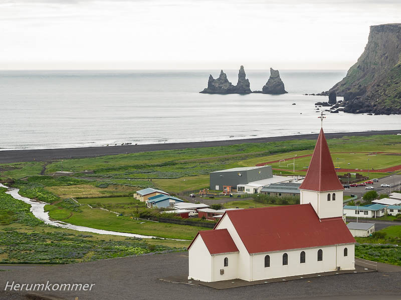
Der Felsen, zum Teil von Lupinen eingerahmt, beeindruckt. Verschiedene Gesteinsschichten sind an der Südfront zu erkennen. An der Ostseite erobern Gras und Bodendecker mühsam Inseln des Lebens in der grauen Sandwüste. The rock, partly framed by lupins, impresses. Different rock layers are visible on the southern front. On the east side grass and groundcover arduously conquer islands of life in the gray desert. Als südlichster Ort Islands gilt Vík í Mýrdal. Obwohl nur ein Dorf ohne Hafen, ist es als wesentlicher Ort zur Versorgung der Südküste bedeutend. Die Felszacken Reynisdrangar, daran kann kein Zweifel sein, sind drei Trolle, die ein Schiff an Land ziehen wollten und dabei vom Sonnenlicht überrascht wurden. Sonnenlicht führt bei Trollen bekanntlich zur sofortigen Versteinerung. In the south Vík í Mýrdal is the southernmost town in Iceland. Although only a village without a port, it is significant as an important place to supply the south coast. The seastack Reynisdrangar, there can be no doubt, are three trolls who wanted to pull a ship ashore and were surprised by sunlight. As a matter of fact, sunlight leads to direct petrification of trolls.
Keine 10 km Luftlinie westlich von Vík liegt das Felstor Kap Dyrhólaey. Eine üble Schotterstraße führt auf die Klippe, auf der ein wuchtiger Leuchtturm trohnt. Bei tief stehender Abendsonne haben wir nach Osten eine gute Sicht zurück auf Reynisdrangar. Die Küste im Westen und die Westmännerinseln liegen im Dunst. No 10 km of air line west of Vík is the rock gate Cape Dyrhólaey. A bad gravel road leads to the cliff, which is dominated by a mighty lighthouse. With low evening sun we have a good view to the east on Reynisdrangar. The coast to the west and the Westmen Islands lie in the haze. Der Skógafoss ist ein hoher Wasserfall nahe der Ringstraße, der in voller Breite wie ein Vorhang vor der Felskante herab stürzt. Das war ein magischer Ort und eine Ikone Islands. Nun sind dort an einem gewöhnlichen Tag in der Vorsaison ca. hundert Fahrzeuge geparkt, einige davon Busse. Es wimmelt von Menschen. Neben dem Wasserfall ist eine Treppe mit Aussichtsplattform errichtet, beide voller Menschen. Es herrscht Partystimmung. Auf uns wirkt das ein wenig, wie Hafengeburtstag. Wir müssen weiter. Am Seljalandsfoss ein ähnliches Bild. Wir lieben diesen Wasserfall, aber so macht er uns keinen Spaß. Wir überlegen sogar, spät abends wiederzukommen, wenn die meisten Menschen weg sind, denn hell ist es ohnehin praktisch immer. Aber dafür sollte es sonnig sein. Kurz entschlossen fahren wir auf die Seljalandsheiði, eine steinige Hochebene unweit des Eyjafjallajökull. Hier liegen noch Schneebretter, auch auf der Jeep-Piste. Die Steigungen und Gefälle sind erheblich und die Piste sehr „geröllig“ rutschig. Der Herumkommer muss das volle Programm des Allradantriebs einsetzen. Wir genießen die Aussicht über die Mäander des Markarfljót. The Skógafoss is a high waterfall near the ring road, which falls down in full width like a curtain in front of the rock face. This was a magical place and an icon of Iceland. Now there are about a hundred vehicles parked on a common day in the pre-season, some of them buses. It is teeming with people. Next to the waterfall is a staircase with viewing platform, both full of people. There is party time. To us this resembles a fun fair. We must go on. At the Seljalandsfoss a similar picture. We love this waterfall, but not under such conditions. We even think of coming back late in the evening, when most people are gone, because there is light practically always anyway. But it should be sunny for good views. Quickly decided we drive up to Seljalandsheiði, a rocky plateau near Eyjafjallajökull. There are still flowe avalanches, on the jeep track, too. The slopes and declines are considerable and the track very „grubby“ slippery. The Aroundgetter has to use the full program of all-wheel drive. We enjoy the view over the meanders of the Markarfljót.
Als wir wieder unten in der Ebene ankommen, braut sich am Eyjafjallajökull eine Wolke wie ein Ufo zusammen, die aber folgenlos bleibt. As we get down again in the plain, a cloud is gathering at the Eyjafjallajökull like a Ufo, but it remains without consequences.
Und bevor wir am Rand des Markarfljót mal wieder einen traumhaften Stellplatz für die Nacht „erobern“, entschädigt uns der Gluggafoss (Fensterwasserfall) für die ausgelassenen Wasserfälle. And before we „conquer“ a wonderful place for the night on the edge of the Markarfljót, the Gluggafoss (window waterfall) compensates for the omitted waterfalls. Auf dem Weg vom Markarfljót nach Hvolsvöllur lockt uns ein Wegweiser ins Vatnsdalur. Wir fahren durch ausgedehnte Forsten mit ausgewiesenen Wanderwegen. Die werden abgelöst von mehr oder weniger landwirtschaftlich genutzten Hügeln. Die recht hübsche Landschaft endet jäh. Die Fiská will gefurtet werden, gleich mehrmals. Einerseits sind es vier Flussarme, die nacheinander gequert werden müssen. Jeder ist eine Herausforderung. Andererseits, in einem durchgehenden Flussbett wäre Furten wohl unmöglich. Die erste Furt ist schnell geschafft. Und wo geht es jetzt weiter? Wo sind möglicherweise unter Wasser tiefe Fahrspuren? Wo führt die Piste auf der anderen Seite weiter, zu welchem Flussarm? Amortised rubber boots On the way from Markarfljót to Hvolsvöllur, a signpost lures us into Vatnsdalur. We drive through extensive forests with marked hiking trails. They are replaced by more or less agriculturally used hills. The pretty landscape ends suddenly. The Fiská wants to be forded, even more than once. On one hand, there are four river arms, which must be crossed one after the other. Everyone is a challenge. On the other hand, fording would probably be impossible in a continuous riverbed. The first ford is done quickly. And where is it going now? Where are possibly deep lanes underwater? Where does the track continue on the other side, to which river?
Jetzt amortisieren sich endgültig die Gummistiefel, die der Herumkommer zu Hause gekauft hat. In denen durchwatet er jedes einzelne der drei weiteren Gewässer, zum Teil durch erhebliche Strömung, und wieder zurück. Und dann sind wir, ruck zuck, jenseits der Fiská unvermittelt in einem alten Lavafeld. Now the rubber boots, which the Aroundgetter bought at home, are now finally amortized. In these he crosses each of the three other waters, partly through considerable currents, and back again. And then we are quickly beyond the Fiská abruptly in an old lava field. Zwischen Hella und Selfoss überquert die Ringstraße die Þjórsá, den längsten Fluss Islands, kurz vor seiner Mündung in den Atlantik. In Sichtweite der Brücke stürzt die Þjórsá in 40 m Breite 6 m tief über den wasserreichsten Wasserfall Islands, den Urriðafoss. Anders als Seljalandsfoss und Skogafoss hat er nicht viel Publicity und kaum Infrastruktur. Darum wird er leicht übersehen. Massively water Between Hella and Selfoss the ring road crosses the Þjórsá, the longest river in Iceland, just before its mouth into the Atlantic. Close to the bridge, at a width of 40 m, the Þjórsá falls 6 m over the waterfall most abounding in water in Iceland, the Urriðafoss. Unlike Seljalandsfoss and Skogafoss, it does not have much publicity and hardly any infrastructure. That is why it is easily overlooked. Die Halbinsel Reykjanes im Südwesten Islands ist vulkanisch aktiv. Lavafelder prägen über weite Strecken das Bild. Und es ist ein Geothermalgebiet. Mehrere Kraftwerke werden hier mit kochend heißem Wasser aus der Erde betrieben. An einigen Stellen tritt die Erdwärme einfach so aus dem Erdboden aus. Ein solches Gebiet ist Seltún / Krýsuvík. Nahe der Straße kochen Schlammlöcher und heiße Quellen, dampft und brodelt es aus Solfataren und Fumarolen. Unweit dieses Geothermalgebiets erfreuen wir uns über den smaragdgrünen See Grænavatn. Foeted color splendor The Reykjanes peninsula in the south-west of Iceland is volcanically active. Lava fields coin the landscape over long distances. And it’s a geothermal area. Several power stations are operated here with boiling hot water from the earth. In some places, the geothermal energy simply leaks from the ground. Such an area is Seltún / Krýsuvík. Near the road, mud holes and hot springs boil, it steams and boils from solfataras and fumaroles. Not far from this geothermal area we enjoy the emerald lake Grænavatn. Und dann begeben wir uns in die Dampfwolken mit dem Geruch von Schwefelwasserstoffen in einer Landschaft, die von der Hitze farbenfroh gestaltet ist. And then we enter the clouds of steam with the smell of hydrogen sulphide in a landscape made colourful by the heat.
Die Blaue Lagune (Bláa Lónið) bei Grindavík ist eines der größten Highlights Islands und eine sehr isländische Erfolgsgeschichte. Mitten in der Halbinsel Reykjanes steht in einem Geothermalgebiet ein Kraftwerk. Das geförderte Wasser ist aber salzhaltig und kann nicht zur Versorgung von Haushalten verwendet werden. Es wird daher zum Erhitzen von Süßwasser und zum Betrieb der Turbinen genutzt. Das Auffangbecken des heißen, mineralhaltigen Wassers wurde zur Blauen Lagune. Blaugrüne Algen, Mineralsalze und Kieselsäure geben dem Wasser eine milchig blaue Farbe. Die bildet einen sehr schönen Kontrast mit der Lava, in der das Wasser steht. Neben der Bade-Lagune, abgegrenzt durch einen hohen Sichtschutz aus aufgehäufter Lava, gibt es einen frei zugänglichen Bereich. Dort haben wir im Licht der untergehenden Sonne die Faszination der Blauen Lagune ausgiebig fotografiert. Sky blue milk The Blue Lagoon (Bláa Lónið) near Grindavík is one of Iceland’s greatest highlights and a very Icelandic success story. In the middle of the Reykjanes peninsula there is a power station in a geothermal area. However, the extracted water is saline and cannot be used to supply households. It is therefore used for heating fresh water and for running the turbines. The collecting pond of the hot, mineral water became the Blue Lagoon. Blue-green algae, mineral salts and silicic acid give the water a milky blue color. It forms a very nice contrast with the lava in which the water stands. Next to the swimming lagoon, separated by high blinds from piled up lava, there is a freely accessible area. There we photographed the fascination of the Blue Lagoon extensively in the light of the setting sun. Ein paar Kilometer südlich vom Geothermalgebiet Seltún / Krýsuvík, an der Atlantikküste, ist einer der größten Vogelfelsen Islands, der Krýsuvíkurberg. Eine Jeep-Piste führt von der Hauptstraße dort hin. Nach etwa drei Kilometern ist für unser Wohnmobil Endstation. Hier führt die Piste steil hinauf durch tief im weichen Boden ausgefahrene Fahrspuren auf eine Anhöhe. Das ist uns zu riskant. Wir lassen das Womo unten stehen und gehen zu Fuß weiter. Fulmars duet A few kilometers south of the geothermal area Seltún / Krýsuvík, on the Atlantic coast, is one of the largest bird rocks of Iceland, the Krýsuvíkurberg. A jeep track runs there from the main road. After about three kilometers there is terminal stop for our motor home. Here, the track leads steeply up on a hill through lanes running deep in the soft ground. This is too risky for us. We leave the camper and go walking.
Die Klippen fallen ca. 50 m steil ab. Unten zerrt der Atlantik mit seinen Wellen am Geröll. Eine Felswand zieht uns mit ihren Farben magisch an. Möwen und Eissturmvögel brüten hier und ziehen ihre Runden. Und Paare singen im Duett. The cliffs drop steeply about 50 m. Below, the Atlantic drags the rubble with its waves. A rock face attracts us magically with its colors. Gulls and fulmars breed here and fly their rounds. And couples sing in duet. Gunnuhver, ein weiteres Geothermalgebiet auf Reykjanes, liegt in der Südwestspitze der Halbinsel. Bei der Anfahrt von Osten her sehen wir zunächst den Leuchtturm Reykjanesviti hinter einer Dampfwolke verschwinden. Die größte Schlammquelle des Landes mit 20 m Durchmesser ist zur Zeit ausgetrocknet. Clouds maker Gunnuhver, another geothermal area on Reykjanes, is located in the southwestern tip of the peninsula. When we arrive from the east, we first see the lighthouse Reykjanesviti disappear behind a steam cloud. The largest sludge source of the country with a diameter of 20 m is currently dried up.
Aber der Dampf faucht und zischt mit ungeheurem Druck aus der Erde. Die frühere Aussichtsplattform hat er zerstört. Anders als in Seltún / Krýsuvík riecht es nicht so sehr nach Schwefelwasserstoff sondern fischig. Meerwasser strömt in 900 -1000 m Tiefe in die Gesteinsschichten des Kap Reykjanes und tritt hier als Dampf aus dem Boden. But the steam hisses and whizes with tremendous pressure from the earth. It destroyed the earlier lookout platform. Unlike in Seltún / Krýsuvík it smells not so much of hydrogen sulphide but fishy. Seawater flows into the rock layers of Cape Reykjanes at a depth of 900-1000 m and exits here as steam from the ground. Die südwestliche Spitze der Halbinsel Reykjanes ist eine von Vögeln umkreiste, schroffe Steilküste. Breakwater rocks The southwestern tip of the Reykjanes peninsula is a rough and steep coastline with many birds flying about.
Eine besonders hohe Klippe lockt den Herumkommer an. Von hier oben ist der Ausblick über den tosenden Atlantik grandios. A particularly high cliff attracts the Aroundgetter. From here the view over the roaring Atlantic is magnificent. Nach einer Woche in Island mit prallem Wetter dachten wir, damit wäre es erst mal vorbei. Aber außer gelegentlichen wolkenverhangenen Tagen, oft nur Stunden, haben wir nach wie vor richtig gutes Reisewetter. Bis auf den nieseligen Tag am Skaftafell hatten wir keinen nennenswerten Regen. In dem kleinen Dorf Stafnes an der Westküste von Reykjanes haben wir auf einem Parkplatz einen guten Übernachtungsplatz gefunden, etwa 200 m vom Leuchtturm Stafnesviti. Mit perfekter Abendsonne fotografieren wir den Turm gegen 21:45 Uhr. Und dann zieht nach Mitternacht Nebel auf. Promotion week reloaded After a week in Iceland with the best of weather, we thought it would be over. But apart from occasional cloudy days, often only for hours, we still have really good travel weather. Except for the drizzly day at Skaftafell we had no appreciable rain. In the small village of Stafnes on the west coast of Reykjanes, we have found a good place to stay in a parking lot, about 200 meters from the lighthouse Stafnesviti. With perfect evening sun we photographed the tower at 9:45 pm. And then, after midnight, fog approaches. Iceland Greenland tour
Diamanten auf schwarzem Samt


Ende der Island-Werbewoche


Schweinebergsgletscher


Der schwarze Wasserfall


Isländischer Wald


Stellplatz ohne Steinschlag


Lavafelder und Sander


Weiche Lavalandschaft


Das kommt von der Neugier


Ganz große Bühne


Insel im Sand


Im Süden


Gluggafoss


Amortisierte Gummistiefel


Massenhaft Wasser


Anrüchige Farbenpracht


Himmelblaue Milch


Eissturmvögel-Duett


Wolkenmacher


Brandungsfelsen


Werbewoche reloaded


